Judkins Park I-90 Before "The Lid"
Background #
I've lived in the Judkins Park neighborhood of Seattle for the last ten years.
The City's own Neighborhood Map Atlas lists the primary name of this neighborhood as Atlantic with Judkins Park
as an alternative name among Colman and Jackson Place.
Seattle Times articles from the 1990s
also highlight the "Judkins-Rejected" nickname, used by residents to since the 1970's, to highlight their discontent
with policy decisions (including transportation) that threatened to disrupt the fabric of the neighborhood.
Interstate 90 runs beneath this neighborhood, encapsulated for a length of 3,300 feet according to the Mount Baker Tunnel wikipedia page. The eastern half of that tunnel has existed since 1940 (according to the previously linked wikipedia article). The western half however was exposed, and covered as part of the creation of a "lid" that developed Sam Smith Park, Jimi Hendrix Park, and the opening of the (potentially soon to be shuttered) Thurgood Marshall Elementary School.
I-90 West and East Tunnel Entrances.
Note the layout of I-90 in the image below. The West and East tunnel entrances can be seen on either
side. 23rd Ave S is visible as the western most street running North/South.
Martin Luther King Jr Way S (Formerly Empire Way) is visible bisecting Sam Smith Park to the East
and Thurgood Marshall Elementary/Jimi Hendrix Park/Northwest African American Museum to the West.
The area in red indicates the rough location of The Lid, as seen in higher detail below.
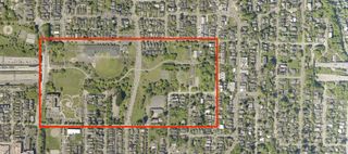
Image Credit: King County 2023
I-90 Lid: Jimi Hendrix Park/Northwest African American Museum - Sam Smith Park
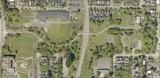
Image Credit: King County 2023
As I've walked and cycled across this green space, I've tried to imagine what this area was like before The Lid existed. I have always assumed there had to be some combination of overpasses, underpasses, onramps, offramps, and maybe even a sidewalk or two allowing the interstate and a neighborhood to co-exist somehow.
After a bit of research on the MOHAI image archives and a visit to the Seattle Room of the Central Library branch, I found out I was generally correct (I believe).
Pre-Lid Condition #
1982: Former West Portal Mt. Baker Ridge Tunnel.
This photo was my first clue, found on the Mount Baker Tunnel
wikipedia page. Looking East, it shows
the West tunnel entrance to I-90 at Yakima Ave S. Current day, this would be underground,
below the current day Bike/Pedestrian Tunnel of Sam Smith Park (See below)
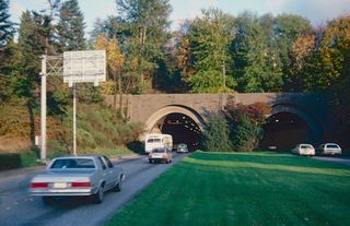
Image Credit: By Steve Morgan, CC BYSA 4.0
The current bike/pedestrian tunnel, opened in 1994, situated on The Lid above the former tunnel portals pictured previously.
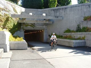
Image Credit: By Robert Ashworth, CC BYSA 2.0
Given the gentle slope of The Lid, it's hard to imagine being in the past, walking South from say Norman Street, and running into an impassible mass of freeway. It's literally hard to imagine.
I looked for available aerial imagery from before the lid's construction, but couldn't really find anything. So I decided to take a trip to the "Seattle Room" of the Central Library branch, which has a collection of Kroll Street Atlases. I was able to find a copy from 1977, which showed the old street configuration in perfect detail.
I took a few photos with my phone of the relevant sheets, georeferenced them, and created the side-by-side map embedded below. Panning and zooming the map can allow you to compare the 1977 Pre-Lid layout with aerial imagery showing the current configuration. Note tha the georeferencing is a best approximation given the fact that I was taking cell-phone shots of these sheets.
Some takeaways from the 1977 Kroll Atlas:
- 23rd Ave S had a full-on bridge over I-90 (
Lake Way) allowing vehicular crossing north/south. - A pedestrian bridge existed near 24th Ave S providing another crossing opportunity.
Empire WaynowMLK Jr Way Sran undisturbed north/south. Users of I-90 crossed via an overpass onLake Way.- Numerous parcels (houses/industrial) were razed to accommodate The Lid and widening of I-90.
AtlanticandDaystreets, running east/west on either side of I-90, were disconnected by the construction of The Lid.
From the MOHAI digital archives (accessed via the University of Washington digital collections) I was able to find two images that provide some real context to the illustrations of the Kroll Atlas.
1983: View of Atlantic Street neighborhood, Seattle.
On the left side of this image you can see I-90, the overpass at
23rd Ave S (closest to the viewer), a faint line that I believe to be
the 24th Ave S pedestrian crossing, and the old tunnel entrance.
Atlantic Street can also be seen to the right, along with the old
Colman School/Current NAAM building.
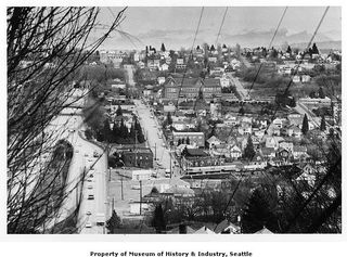
Image Credit: MOHAI, Seattle Post-Intelligencer Photograph Collection, 9876
1954: View of Rainier Avenue and Lake Way looking east.
In this earlier image, you can see parcels that no longer exist in the
circular patch of land between the offramp of I-90 at Rainier and
Rainier itself. Day street is also visible.
I also just enjoy seeing how "filled out" the neighborhood looks. The structures are mostly low-density single-family homes of course, but it seems clear that there is an established neighborhood.
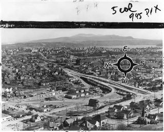
Image Credit: MOHAI, Seattle Post-Intelligencer Photograph Collection, 17965
I've appreciated learning about this small bit of history of my neighbhorhood. As I've mentioned previously, it's hard to imagine what walking through this area would be like before The Lid. The Lid, I assume, creates such a different experience for users of the space that it's just hard for me to imagine the sensory experience of being able to hear and look down at the interstate, a few blocks from my house.
Additionally, while learning about "what was" the previous condition and comparing it to "what is" today, I've enjoyed learning a bit about "what could have been", like a proposed I-90 offramp at 23rd Ave S, successfully rejected by neighborhood activism. The challenges of development, displacement, and gentrification that the neighborhood faces today, as well as the hard work of community members working to combat those challenges, have been present in previous forms for decades.
I'm hopeful to learn more about how this neighborhood has evolved over time, specifically using transportation as a lens.
Additional Reading #
- Historylink.org : Residents file suit to stop Interstate 90 project on May 28, 1970.
- Seattle Times: Forget Ramp, Judkins-Rejected Says -- Lingering I-90 Proposal Still Alive Despite Neighborhood Opposition
- Seattle Times: Rebuilding A Neighborhood -- No Longer `Rejected,' Judkins Park's On Its Way Back Up